

 Magistrates' Courts "Lower Courts" Act, 1944
R 385
National Heritage Resources Act, 1999 (Act No. 25 of 1999)NoticesDeclaration of the Thulamela Archaeological Site situated in the Kruger National Park, Limpopo as a National Heritage Site |
Notice No. 5192
13 September 2024
GG 51205
Department of Agriculture, Land Reform and Rural Development
By virtue of the powers vested in the South African Heritage Resources Agency (SAHRA), in terms of section 27(5) of the National Heritage Resources Act, 1999 (Act No. 25 of 1999), SAHRA hereby declares the Thulamela Archaeological site, on Farm Thulamela Ruin no 7-MU, Vhembi District Limpopo in Pafuri region of the Kruger National Park, as a National Heritage Site.
Statement of Significance
Thulamela, the "Place of Giving Birth", is a dry stone-walled hilltop site overlooking the Luvuvhu River floodplain in the Pafuri section of the Kruger National Park. It was occupied by the ancestors of the Shangaan, Tsonga, and Venda from around the 13th to 17th centuries and was at the centre of what was once a thriving ivory-gold trade route, as evidenced by glass beads, bronze, Chinese porcelain, ivory bracelets, gold, and textiles. Similar sites have been found in the immediate vicinity at Makahane, Matjigwili and Shilowa, across the borders in Zimbabwe, at Masorini in Kruger and related sites in Mozambique, and as far west as Mapungubwe and Botswana. The combined evidence of these sites indicates that the East Coast trade network stimulated the establishment of high-status chieftainships all along the Limpopo corridor based on the exchange of gold, ivory and leather for the exchange of glass beads, porcelain, and cloth. The Royal Palace is understood to have been located at the top of the Thulamela hill and the site indicates class division developed as a result of this trade networks. The power base of these settlements waned after the Portuguese waned after the discovery of the sea route to India and developed the slave trade on the east coast.
Thulamela is thus part of the greater story of the "peopling of Southern and South Africa". It is an evolving story of the past that is constantly being studied and updated. It confirms the existence of a complex state system in pre-colonial South Africa, dispelling the propaganda of an uncivilised landscape propagated by colonial and Apartheid regimes. The abundance of archaeological material discovered at Thulamela significantly shaped our understanding of pre-colonial political states and helped redress past injustices and misconceptions."
Schedule
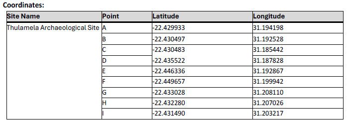
The demarcation of the sites is as follows:
|
SITE NAME |
FARM / ERF NO |
TOWN |
MUNICIPALITY |
PROVINCE |
SG Diagram |
|
|
Local Municipality |
District Municipality |
|||||
|
Thulamela Archaeological Site |
Thulamela Ruins no 7-MU |
Thulamela Local Municipality |
Vhembe District Municipality |
Limpopo |
5823/200 |
|
END


